iOS point mapping app
Discussion


Our archery club is building a new field archery course. We need a simple app just to measure accurately between points that we have no direct access to.
Ie we can do a-b and c-d but we need the measurements between b-d.
I’m assuming this is a fairly standard ask using GPS but is there one that you would recommend?
Right, slight miscommunication on my part.
The plan is an ‘easy access’ course which can be used by archers not usually capable of doing a normal field course.
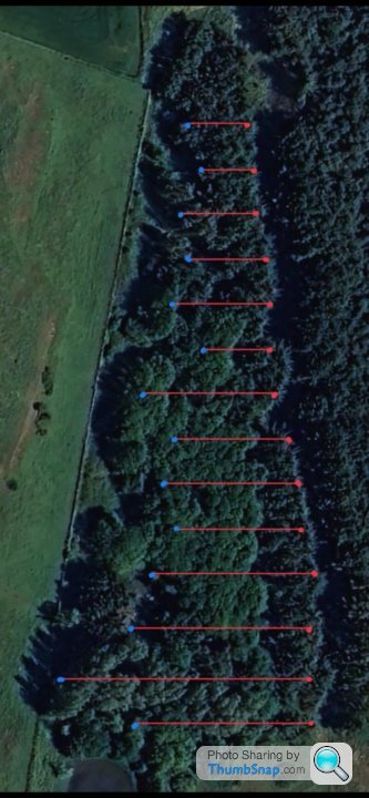
The idea is shoot from the red points (a path) to the blue ( targets) We can get the shooting distances as obviously there has to be line of sight but being woodland they can’t be as neat and tidy as on the picture. Some will have to be at an angle making the targets potentially closer together and we need them a certain distance for safety. The thing we need is a method to plot the whole course so we can ensure the targets are far enough apart.
That was a longwinded way to say we can get access to all points but just not from all directions. We just need a way to connect all the points.
The plan is an ‘easy access’ course which can be used by archers not usually capable of doing a normal field course.
The idea is shoot from the red points (a path) to the blue ( targets) We can get the shooting distances as obviously there has to be line of sight but being woodland they can’t be as neat and tidy as on the picture. Some will have to be at an angle making the targets potentially closer together and we need them a certain distance for safety. The thing we need is a method to plot the whole course so we can ensure the targets are far enough apart.
That was a longwinded way to say we can get access to all points but just not from all directions. We just need a way to connect all the points.
If you can get the gps positions for each shooting position and target position you could put any combination of 2 locations into something like this
https://boulter.com/gps/distance/?from=53.863883+-...
Those coordinates are the shooting line and 30m markers on our field (rough positions taken from a historical image on google earth where you could see the distance markers). The link about only shows it at 29m, i don't think they thought about people wanting it down to cm level. I'm sure there are other pages that would show it in more detail.
Here is a link to an excel file that does similar, and shows those coordinates to be 29.938m https://www.contextures.com/excellatitudelongitude...
I'm sure that excel file could be modified so that you can put the coordinates for x shooting/target positions and it show its distance from the previous target.
I don't know the rules for setting a field archery up, we are a target archery club where distance allowances are measured in the cm.
Gassing Station | Computers, Gadgets & Stuff | Top of Page | What's New | My Stuff