Free OpenStreetMap maps on Garmin Sat Navs
Discussion


The maps on my 2015 V8 Vantage S were last updated in 2013?!?!?! Given that I live in Dubai and the roads update here weekly, the sat nav is nigh on useless.
I've been playing around with using Open Street Map data and I have managed to get bang-up-to-date street maps on the Garmin in the car for free. I got the maps from http://garmin.openstreetmap.nl/ and they have up-to-date maps for the whole world for free.
Given that it is based on OpenStreetMap, it may not be the most accurate but the Garmin maps from 2013 are hardly accurate either!!
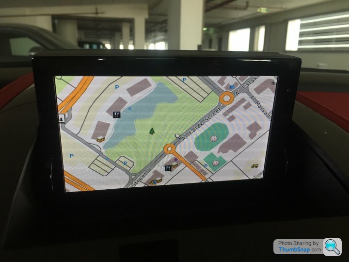
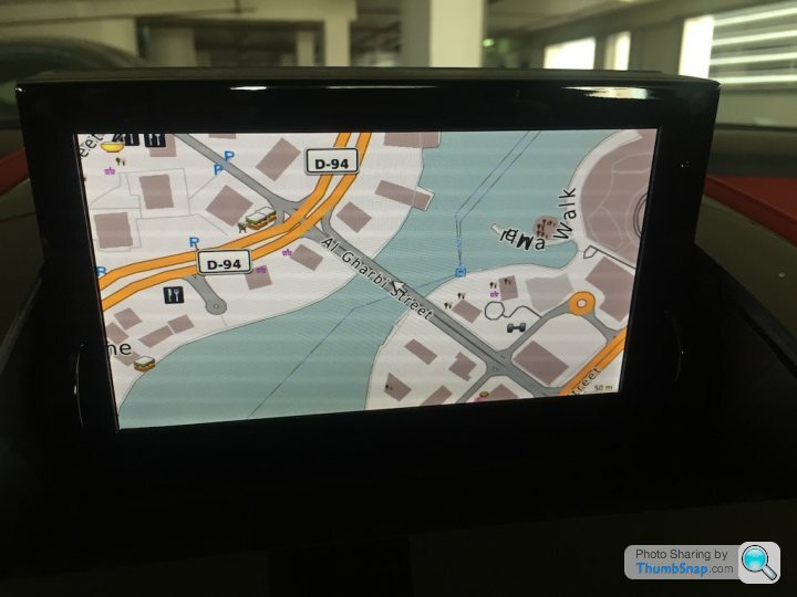
Below are some screen-shots of the new maps in the car. They seem to work well, too. If anyone is interested, I'd be happy to do a little write-up on how I did it.
I've been playing around with using Open Street Map data and I have managed to get bang-up-to-date street maps on the Garmin in the car for free. I got the maps from http://garmin.openstreetmap.nl/ and they have up-to-date maps for the whole world for free.
Given that it is based on OpenStreetMap, it may not be the most accurate but the Garmin maps from 2013 are hardly accurate either!!
Below are some screen-shots of the new maps in the car. They seem to work well, too. If anyone is interested, I'd be happy to do a little write-up on how I did it.
OK, here we go.
Firstly you need to remove the SD card from the sat nav. This link shows where the unit is located on a V8 Vantage https://www.6speedonline.com/forums/aston-martin/3...
The first thing I did was to back-up the SD card in case I messed something up. I use a Mac and used Disk Utility to create a disk image of the SD card. Right click the disk image and then select "New Image from Untitled". There's plenty of other guides on the internet on how to back-up (and restore) SD cards as disk images.
I downloaded the Garmin compatible maps from http://garmin.openstreetmap.nl/. I have found the best results with choosing the Generic Routable (NOT the new style) and including the Mapnik TYP file. I've found that the New Style maps do not allow the selection of a TYP file and consequently do not look very good on the sat nav in the car. The third option is to select the region. With these settings, most of the regions are ready for download immediately. I chose Asia/United Arab Emirates, which was available, and I noticed that Europe/United Kingdom is also immediately available. If a region is not available, or you manually choose the tiles, it can be built on demand, but it takes a LONG time. I've done both since I wanted the UAE and Oman on the same image, and they emailed me back after about 11 days to say my image was ready for download.
If the image is available, click the Download button and it gives you several format options. The one you need is the osm_generic_gmapsupp.zip file. The other files can also be downloaded and used in other Garmin's software, such as Base Camp, and I used this technique to copy the maps to my cycle computer, for example, but you need the osm_generic_gmapsupp.zip file for our Aston Martin sat navs.
When this has finished downloading, unzip it and you will have a gmapsupp.img file that you can copy onto your SD card.
Looking at the SD card, there is a garmin folder and in there are 3 files gmapsupp.gma, gmapsupp.img and gmapsupp.unl. Some sat navs let you have multiple supplementary image files with different names, but it seems this one does not as it would not recognise anything that wasn't called gmapsupp.img. Consequently, I created a new folder called Backup and moved all 3 files beginning with gmapsupp in there so I could restore them quickly if I needed to. I then copied the gmapsupp.img file I unzipped into the garmin folder, ejected the SD card, and poppoed it back into the sat nav in the car.
That's it!!
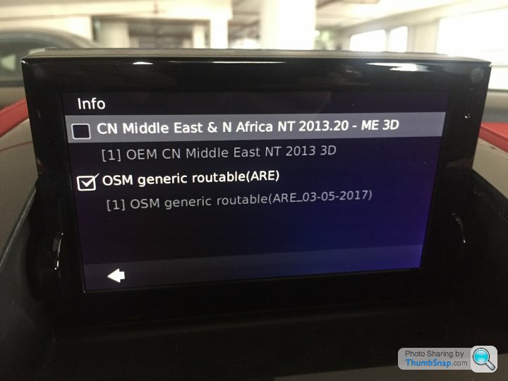
You can verify that the item is working by selecting Settings|Map|Info from the sat nav in the car. You should see the new OSM file (see below).
I wanted to specifically see what this new map could do so I unselected the first official Garmin map so I knew I was looking at the OSM maps. The screenshots in my previous post are those. It looks good and it successfully routed me to a destination that wasn't previously in the old maps since it was built in the past 2 years. I now have both items selected so I get the up-to-date maps and the 3D buildings, and there is always the possibility that there are points of interest on the Garmin maps that are not on the Open Street Map maps.
I am not affiliated with openstreetmap.nl in any way, and I don't even know who runs it, but they state that their goal is to advance the usage of Open Street Map project. They don't charge anything for the maps but they do have a donate button on their website. I have used their maps in a removable Garmin device in my other car and also my Garmin cycle computer and had no issues, so I will probably donate something to them since they provide a good function.
I do not believe there are any legal issues with this since the OSM data is freely available and usable.
I hope others have similar success.
Firstly you need to remove the SD card from the sat nav. This link shows where the unit is located on a V8 Vantage https://www.6speedonline.com/forums/aston-martin/3...
The first thing I did was to back-up the SD card in case I messed something up. I use a Mac and used Disk Utility to create a disk image of the SD card. Right click the disk image and then select "New Image from Untitled". There's plenty of other guides on the internet on how to back-up (and restore) SD cards as disk images.
I downloaded the Garmin compatible maps from http://garmin.openstreetmap.nl/. I have found the best results with choosing the Generic Routable (NOT the new style) and including the Mapnik TYP file. I've found that the New Style maps do not allow the selection of a TYP file and consequently do not look very good on the sat nav in the car. The third option is to select the region. With these settings, most of the regions are ready for download immediately. I chose Asia/United Arab Emirates, which was available, and I noticed that Europe/United Kingdom is also immediately available. If a region is not available, or you manually choose the tiles, it can be built on demand, but it takes a LONG time. I've done both since I wanted the UAE and Oman on the same image, and they emailed me back after about 11 days to say my image was ready for download.
If the image is available, click the Download button and it gives you several format options. The one you need is the osm_generic_gmapsupp.zip file. The other files can also be downloaded and used in other Garmin's software, such as Base Camp, and I used this technique to copy the maps to my cycle computer, for example, but you need the osm_generic_gmapsupp.zip file for our Aston Martin sat navs.
When this has finished downloading, unzip it and you will have a gmapsupp.img file that you can copy onto your SD card.
Looking at the SD card, there is a garmin folder and in there are 3 files gmapsupp.gma, gmapsupp.img and gmapsupp.unl. Some sat navs let you have multiple supplementary image files with different names, but it seems this one does not as it would not recognise anything that wasn't called gmapsupp.img. Consequently, I created a new folder called Backup and moved all 3 files beginning with gmapsupp in there so I could restore them quickly if I needed to. I then copied the gmapsupp.img file I unzipped into the garmin folder, ejected the SD card, and poppoed it back into the sat nav in the car.
That's it!!
You can verify that the item is working by selecting Settings|Map|Info from the sat nav in the car. You should see the new OSM file (see below).
I wanted to specifically see what this new map could do so I unselected the first official Garmin map so I knew I was looking at the OSM maps. The screenshots in my previous post are those. It looks good and it successfully routed me to a destination that wasn't previously in the old maps since it was built in the past 2 years. I now have both items selected so I get the up-to-date maps and the 3D buildings, and there is always the possibility that there are points of interest on the Garmin maps that are not on the Open Street Map maps.
I am not affiliated with openstreetmap.nl in any way, and I don't even know who runs it, but they state that their goal is to advance the usage of Open Street Map project. They don't charge anything for the maps but they do have a donate button on their website. I have used their maps in a removable Garmin device in my other car and also my Garmin cycle computer and had no issues, so I will probably donate something to them since they provide a good function.
I do not believe there are any legal issues with this since the OSM data is freely available and usable.
I hope others have similar success.


Ian_UK1 said:
Thanks for the write-up.
Following your instructions, I've managed to create 2 new SD Cards with maps for UK and France respectively - all seems to work perfectly.
No problem. Having multiple SD cards with different maps is a great idea, especially given that the cards are so cheap and they are so easy to swap.Following your instructions, I've managed to create 2 new SD Cards with maps for UK and France respectively - all seems to work perfectly.
David W. said:
Is ther a business opportunity here for someone selling the updated SD cards?
I'm not sure if the Open Street Map license allows for sale of items based on their data. Maybe it does, I haven't checked, but it is so simple to do I couldn't really justify paying anyone for it.Gassing Station | Aston Martin | Top of Page | What's New | My Stuff