Confusing Junctions / Road Layouts
Discussion


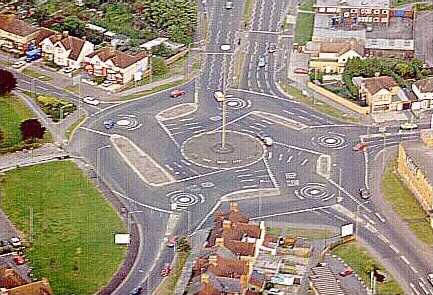
Have been meaning to start this thread for a while, but only remembered yesterday after navigating the junction below and (once again) seeing confusion from drivers as to how they should go about turning their desired direction.
It's fairly local to me and, especially in the dark, seems to catch folk out. It's not particularly confusing when looking at it as a still image on Street View, but I've been through it as a passenger a couple of times where the driver has said something along the lines of "WTF do I do here?" on its approach.
I'm sure the UK can throw much more unusual stuff than this at us, though. Give me your best!
http://goo.gl/maps/ju19p
although there is a lot of paint and made to look a mess it's not too bad.
what on the other hand do you do if you come from the road at the top of the page on this link
https://maps.google.co.uk/maps?q=preston+brook&...
and want to turn left? you've got to drive across the other road to accomplish this.
if on the other hand you want to turn right, you'll have to do a left turn and then immediately do a 'U' turn in the next junction, possibly requiring a shunt to make the 'U' turn.
looking at he first one, coming from the direction of the photo, and wanting the road going off up the photo, i would turn right/left at the first opening. If coming the other way would turn left/left at that'first opening' But the Keeep Left bollard has me thinking, perhaps the two way road markings on the 'side raod' may only apply to the road coming in at right angles, but then wqould the keep left still apply?
silverfoxcc said:
looking at he first one, coming from the direction of the photo, and wanting the road going off up the photo, i would turn right/left at the first opening.If coming the other way would turn left/left at that'first opening' But the Keeep Left bollard has me thinking, perhaps the two way road markings on the 'side raod' may only apply to the road coming in at right angles, but then would the keep left still apply?
Disobeying the keep left bollard is foolhardy. It is there for a reason.Maypole Road (south) to Kelvedon Road
Leave the bollard on your right, go past the signpost, turn right then left.
Prince of Wales Road to Kelvedon Road
Turn right into Maypole Road then as above. I bet that some people will turn right across the gap in the hatching directly into Kelvedon Road. However, if you take a closer look at the way the lines are angled you will see that it is there for a different traffic stream (see below).
Kelvedon Road to Maypole Road (south)
Enter Prince of Wales Road via the gap in the hatching then left into Maypole Road. That said, there is an alternative here. Turn right before the signpost then left into Maypole Road. It is counter intuitive and risky though because traffic emerging from Prince of Wales Road would not expect it.
silverfoxcc said:
The second one loooks straightforward. I cant see any problems there.If you were to make the 'main road' at present left to bottom. left to right, it becomes a normal cross roads. the road markings shouldn't make much difference to your actions. or is there something else?
Although the layout looks similar, there are two distinct differences. It lacks both the island with bollard/signpost and the hatching/gap.Northwich Road (south) to Barker's Hollow Road
A straightforward right turn.
Higher Lane to Barker's Hollow Road
Turn right into Northwich Road then as above.
Barker's Hollow Road to Northwich Road (south)
Proceed across the single dotted line onto A533 passing in front of traffic waiting to emerge from Higher Lane.
This is a far more dangerous junction that the first one. Take the following scenario. You're going from Barker's Hollow Road to Higher Lane. Although the majority of traffic may be staying on the main road you have no way of knowing if someone cba to indicate that they are going 'straight on' - i.e. from Northwich Road to Higher Lane.
Edited by Red Devil on Monday 10th December 14:33
How about this - http://goo.gl/maps/rZqVV - a not-quite-roundabout where staying on the A91 west - east involves a right turn and going north-south on the A823 involves a give way, left turn, give way, right turn, then picking the right lane at the next junction (both marked A823) then a left slip (but not into the blokes driveway!) then finally a give way.
Start here - http://goo.gl/maps/AkHuW and see if you can get to Dunfermline. Needless to say this is an island of 40mph amongst a set of NSL approach roads...
Start here - http://goo.gl/maps/AkHuW and see if you can get to Dunfermline. Needless to say this is an island of 40mph amongst a set of NSL approach roads...
The Boundry Road / Cromer Road junction in Norwich isn't the easiest to navigate, depending upon your route, if you're unfamiliar with it.
http://goo.gl/maps/x8ZTs
If you're travelling from the west and want to turn south, you have to turn north and go around the loop.
http://goo.gl/maps/x8ZTs
If you're travelling from the west and want to turn south, you have to turn north and go around the loop.
alangla said:
How about this - http://goo.gl/maps/rZqVV - a not-quite-roundabout where staying on the A91 west - east involves a right turn and going north-south on the A823 involves a give way, left turn, give way, right turn, then picking the right lane at the next junction (both marked A823) then a left slip (but not into the blokes driveway!) then finally a give way.
Start here - http://goo.gl/maps/AkHuW and see if you can get to Dunfermline. Needless to say this is an island of 40mph amongst a set of NSL approach roads...
Ah, been there done that. Yetts o'Muckhart on the way back from Auchterarder to the Kincardine Bridge after one of our Highland trips. The awkward bit is having to give way immediately after emerging onto the northbound carriageway of the A91 - https://maps.google.co.uk/?ll=56.197251,-3.604546&...Start here - http://goo.gl/maps/AkHuW and see if you can get to Dunfermline. Needless to say this is an island of 40mph amongst a set of NSL approach roads...
Fortunately there is a very good sightline to the southbound A91 so, if nothing is coming from that direction, you can plant it and keep going.
LemonGrove said:
Looks bad enough for the train drivers..... 
They all look pretty straightforward really, except for the magic roundabout (never encountered by me... yet). Guess in the heat of the moment / at speed / night / heavy traffic it might be different.
Mine - the Chiswick roundabout, J1 M4/A4/A406 . Well signed, well marked, but every single time I encounter it (usually 6 pm weekdays), absolute carnage. Left turners in right hand lane and vice versa.
It's hard to tell whether it's poor folks from out of town who have got caught out in the wrong lane with the congestion or rude twonks trying to gain an advantage by using the wrong lane.


Gassing Station | Roads | Top of Page | What's New | My Stuff