OS Maps - Digital Download Subscription?
Discussion


I bought an OS Explorer map recently, with a digital download code. I found it really useful to have the map on my phone, but I can't seem to find where to buy downloads for more maps (without buying the paper versions).
As far as I can tell, I'd have to pay a monthly subscription, which would get me access to all available maps, however, it says you can also download them to your 'phone.
Surely it can't be right that I could pay a one-off £2.99 subscription for a month, and download every map I need (realistically only about 5 or 6), then cancel the subscription? If I was to buy the paper maps to get the codes, it would be about £50.
I have no need to subscribe monthly just to occasionally get access to a map, so I'm wondering how it works? Anyone enlighten me?
Thanks.
dr_gn said:
Thanks both. So the maps on subscription would be available on your account while you subscribe, but the ones bought with a paper map are on your account for good?
I think that's correct, but I have the subscription so couldn't be 100% sure!The annual subscription is worth a look for £24. You can share it across multiple devices too.
No substitute for a proper map if you are going to remote areas, but for knocking about it's a useful thing.
dr_gn said:
Thanks both. So the maps on subscription would be available on your account while you subscribe, but the ones bought with a paper map are on your account for good?
Yes that’s correct, I’ve dipped in and out of the subscription (since out and about less in the winter) and the maps I own are always available whether subscribed or not.Thanks all.
Is there a way of locking the map type to the smallest scale (i.e. 1:25000) ? One thing I find annoying is how it switches to a larger scale as soon as you zoom out slightly. I end up zooming out, scrolling, then zooming back in again after I've found a waypoint. I'd rather just zoom out and keep the larger scale.
Is there a way of locking the map type to the smallest scale (i.e. 1:25000) ? One thing I find annoying is how it switches to a larger scale as soon as you zoom out slightly. I end up zooming out, scrolling, then zooming back in again after I've found a waypoint. I'd rather just zoom out and keep the larger scale.
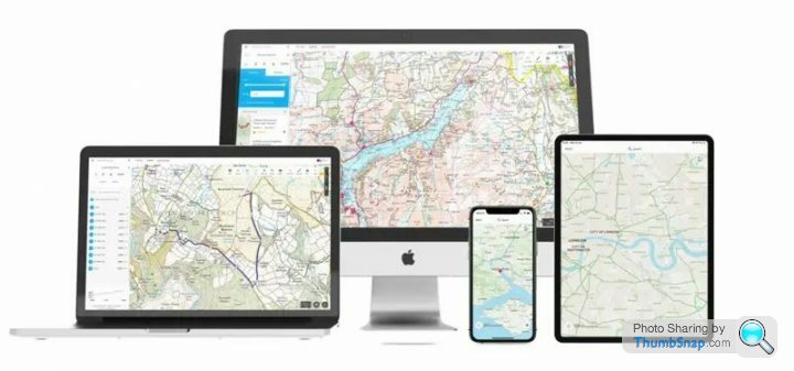
I've just taken out a 1 year sub to the OS app, been using their app on my iPhone for a few years but only using maps I've downloaded from the scratch off codes from their paper maps I've purchased. Nice to now have full access to all their maps, and to be able to create routes on my MacBook and sync them to my iPhone.
Edited by Big Stevie on Monday 13th February 00:07
The OS Maps app is actually very good - I'm a pretty experienced hiker of many years and always like to use a paper map, but these days I plot the routes on the Maps app and use that. Still check on the paper map where I'm going but it's very useful to be able to checkpoint yourself right onto the nearest feature and see an accurate distance remaining to work out timings.
Tankrizzo said:
The OS Maps app is actually very good - I'm a pretty experienced hiker of many years and always like to use a paper map, but these days I plot the routes on the Maps app and use that. Still check on the paper map where I'm going but it's very useful to be able to checkpoint yourself right onto the nearest feature and see an accurate distance remaining to work out timings.
I'm looking forward to using it in anger. I was browsing the Garmin devices and then realised I had the OS app but hadn't bothered with the subscription, and then found out it would give me everything I wanted from a Garmin device. Been playing around with it today and it does appear good. Tomorrow I'll be creating a short local route I know, using my MacBook, syncing it to my phone and testing it out, along with my new Adidas Terrex walking boots.
One thing I noticed today whilst following a route I'd created was that when following the line of my route it was difficult to see the arrow marker indicating where I was, the red route line was too thick making the arrow almost impossible to see. Thankfully this can be edited by pressing on 'Edit' then on the 'Style' icon where you can make the line thinner, change its colour and also adjust its level of transparency. I'll make sure I do this in future.
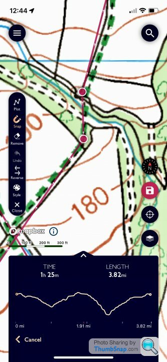
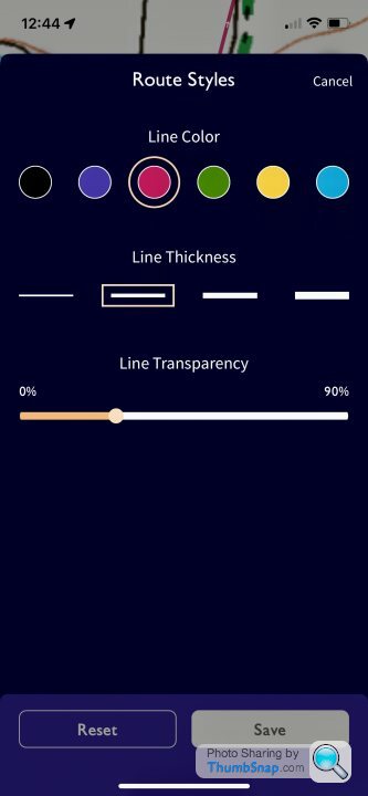
Done a few more short (5-7miles) walks testing out the OS Maps app, pleased with it so far. Still need to experiment with getting the route line to the correct thickness and transparency so I can still see the footpath marking underneath it. For anyone who walks/runs/cycles using maps then the OS Map app is a bargain as £28/year.
I really like the app, it’s made finding routes/calculating distances/navigating while walking so much easier. I had a load of paper OS maps with free download already so just loaded these into the app and good to go.
Best bit for me is that you can see if you’re heading down the wrong path in real time - no more getting half a mile down the wrong track and doubling back (with a pissed off Mrs!)
Best bit for me is that you can see if you’re heading down the wrong path in real time - no more getting half a mile down the wrong track and doubling back (with a pissed off Mrs!)

Slightly off topic but we've just come back from a week in the Peak District. One day we popped over a stile and on the other side was a slightly flustered lady twirling a paper map around. "Excuse me" she said. "Is that the way to the town". Given we were in the middle of nowhere I did have to tell her not to get her hopes up, but the very small village we had just walked through did have a nice pub.
Back on topic, the app is excellent. One thing which is great is that you can share it across devices so you can look and plan routes on an ipad and then transfer it to your phone for when you are out and about.
Back on topic, the app is excellent. One thing which is great is that you can share it across devices so you can look and plan routes on an ipad and then transfer it to your phone for when you are out and about.
i used to use a garmin edge 800 with os maps mini card insert for years so i could use the gps and route planning via garmin connect on an os map. this was primarily for cycling as the edge and hadlebar attachment are small and unobtrusive plus it was pretty robust. i also used it for hiking.
however i broke the on/off button last year (a common problem it seems) and was using a pen to turn it on until i snapped something on the 'motherboard'...i should have used the simple online fix of affixing a small piece of rubber to replace the on/off switch.
i got a new edge for christmas but they dont have mini sd slots anymore and it was seemingly too advanced to download the garmin compatble os maps system, which appears to be discontinued so we returned it. i need to do some proper research but it doesnt seem like the newest and most advanced garmins have any capability to OS mapping which renders them useless for me as i dont like garmins mapping or OSM's. so this thread is of some interest...my only concern of phone map is keeping my mapping sperate from my potential emergency system (phone) and the battery usage - appreciate battery packs etc...but how power hungry is the phone app?
when hiking i still carry/carried paper maps but found the gps invaluable for ensuring going down correct route, especially in hill country with ill defined paths and where multiple paths existed and a compass bearing was not necessarily clear cut, so fols how is the battery drain when using the app and anyone use it for cycling too?
thanks
Gassing Station | Holidays & Travel | Top of Page | What's New | My Stuff