Heathrow /Google Maps
Discussion
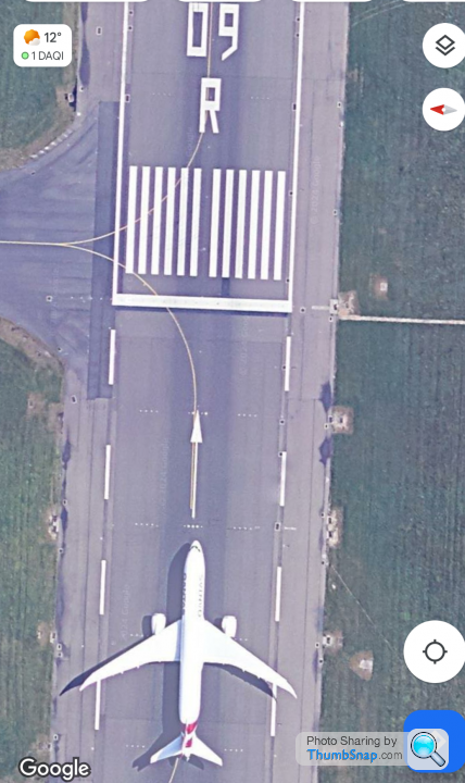
I’ve just been looking at the sat views of Heathrow for other reasons, and idly noticed there are almost no planes in picture whatsoever. There is the old Concorde,an aircraft lining up on 09R and one on a taxiway by the southern perimeter road. Not a single one at any of the terminals or air bridges. Obviously this never happens.I can’t even think it was close to being like that at the height of covid or volcano gate? This must be some sort of editing done on purpose. I can only think it’s for some sort of security reason that thick old me doesn’t get. Anyway, I’ve never seen that before, and when did it become a thing? Answers on a postcard?
normalbloke said:
I’ve just been looking at the sat views of Heathrow for other reasons, and idly noticed there are almost no planes in picture whatsoever. There is the old Concorde,an aircraft lining up on 09R and one on a taxiway by the southern perimeter road. Not a single one at any of the terminals or air bridges. Obviously this never happens.I can’t even think it was close to being like that at the height of covid or volcano gate? This must be some sort of editing done on purpose. I can only think it’s for some sort of security reason that thick old me doesn’t get. Anyway, I’ve never seen that before, and when did it become a thing? Answers on a postcard?
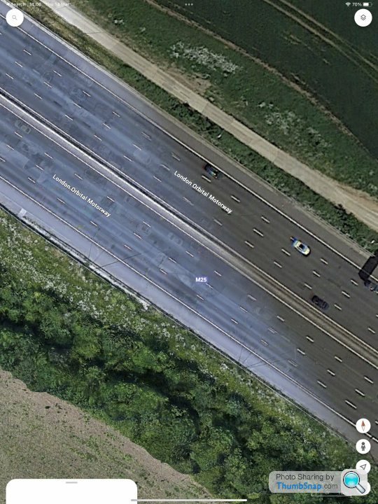
Think it’s an algorithm google use to try to remove non static objects like moving cars and pedestrians etc from the maps, it obviously picks up aircraft taxiing and parked also. If you look at the m25 that’s got no cars either. Think it started about 5 years ago.
I think it’s to make google maps better maps for navigation.
Edited by u-boat on Thursday 14th March 10:01
u-boat said:
Think it’s an algorithm google use to try to remove non static objects like moving cars and pedestrians etc from the maps, it obviously picks up aircraft taxiing and parked also. If you look at the m25 that’s got no cars either.
Think it started about 5 years ago.
I think it’s to make google maps better maps for navigation.
Plenty of vehicles on the M25 show on Google Maps for me, even at the Heathrow section. Think it started about 5 years ago.
I think it’s to make google maps better maps for navigation.
Edited by u-boat on Thursday 14th March 10:01
Edit: and Schipol’s gates are full. Strange!
Could just be the most recent imagery was taken during the pandemic when no one was using the airport.
Gatwick has a lot of planes parked (easyJet and BA) but none at the gates, Luton, Manchester and Edinburgh have aircraft at the gates and in transit so those three are probably using newer or older satellite imagery.
EDIT: there is what looks like a QANTAS 787 on runway 09R.

Gatwick has a lot of planes parked (easyJet and BA) but none at the gates, Luton, Manchester and Edinburgh have aircraft at the gates and in transit so those three are probably using newer or older satellite imagery.
EDIT: there is what looks like a QANTAS 787 on runway 09R.

Edited by captain_cynic on Thursday 14th March 10:46
captain_cynic said:
Could just be the most recent imagery was taken during the pandemic when no one was using the airport.
Gatwick has a lot of planes parked (easyJet and BA) but none at the gates, Luton, Manchester and Edinburgh have aircraft at the gates and in transit so those three are probably using newer or older satellite imagery.
EDIT: there is what looks like a QANTAS 787 on runway 09R.

I did mention the 3 visible planes in my op, but still odd. Can’t even see it being like that during covid.
Gatwick has a lot of planes parked (easyJet and BA) but none at the gates, Luton, Manchester and Edinburgh have aircraft at the gates and in transit so those three are probably using newer or older satellite imagery.
EDIT: there is what looks like a QANTAS 787 on runway 09R.

I did mention the 3 visible planes in my op, but still odd. Can’t even see it being like that during covid.
Edited by captain_cynic on Thursday 14th March 10:46
The person who sends out the aircraft parking charges for Heathrow Airport Holdings is a bit lazy and instead of going around the airport counting actual aeroplanes, just uses Google Maps to work out how long the aircraft have been parked there. Each day he logs in, counts the airliners on the image and sends the owners a bill for another day's parking. The airlines have got wise to this and bung Google some dollars to remove their aircraft from the picture. Obviously anything on the runway or taxiway isn't parked so won't be charged, so they can be left in the shot.
The lady who does the parking charges for Paris Charles De Gaulle Airport is a bit brighter and less lazy, so there is no point editing the image there, hence all the airliners.
The lady who does the parking charges for Paris Charles De Gaulle Airport is a bit brighter and less lazy, so there is no point editing the image there, hence all the airliners.
Tony1963 said:
u-boat said:
Think it’s an algorithm google use to try to remove non static objects like moving cars and pedestrians etc from the maps, it obviously picks up aircraft taxiing and parked also. If you look at the m25 that’s got no cars either.
Think it started about 5 years ago.
I think it’s to make google maps better maps for navigation.
Plenty of vehicles on the M25 show on Google Maps for me, even at the Heathrow section. Think it started about 5 years ago.
I think it’s to make google maps better maps for navigation.
Edited by u-boat on Thursday 14th March 10:01
Edit: and Schipol’s gates are full. Strange!
Riley Blue said:
Very few vehicles on my view of Google Maps until you get round to the south near Brooklands where the imagery date obviously changes and the vehicle count abruptly increases.
Yeah the newer data seems to be removing them, check out here between the join between Oder and newer imagery where the cars have been removed but you can still see shapes in the middle,
Either way it seems to be an algorithm doing it as it’s increasing everywhere as imagery gets updated etc.
MrBig said:
I noticed this too, just assumed it was taken during the heights of Covid.
It definitely started pre covid but seems to vary a lot still. During covid all the airports were full not empty, seems like some airports have them removed and not others, plus some airports where aircraft that are parked remotely are shown and those on air bridges have been removed.
it’s a shame as I liked all the 3d aircraft in google earth 3d imagery.
Edited by u-boat on Thursday 14th March 14:20
Slightly O/T, but on the topic of redacted airborne mapping data, I was recently looking for some of Defra's LiDAR survey data - if you look at an overview map...
https://environment.data.gov.uk/explore/13787b9a-2...
...and select any of the layers, there's an interesting gap in the coverage in Yorkshire.
Whether someone just didn't want the survey aircraft spending a lot of time tediously tooling backwards and forwards over the area as it might interfere with the radar coverage for *just* the wrong few minutes, or giving your potential enemies very precise topographic maps in the vicinity of a strategic defence asset wasn't deemed to be a great idea, I don't know. I haven't checked to see if the actual tiles are available for download and it's just the preview that's been nobbled.
Edited by eharding on Thursday 14th March 16:15
Taozzz said:
One thing supporting the 'during covid' theory for Heathrow is that all parking area are 99% empty in the satellite view.
During covid the airports were full of parked aircraft as they weren’t flying much. It’s the exact opposite of what’s happening in this google algorithm that’s being rolled out. Some information here
https://support.google.com/earth/thread/195900030/...
https://nerdtechy.com/why-google-maps-remove-airpl...
It’s a google algorithm that compares lots of static images and removes non static objects from certain areas. It’s obviously not happening everywhere and even at some airports it removes some aircraft from air bridges but not remote stands.
Gassing Station | Boats, Planes & Trains | Top of Page | What's New | My Stuff


