Isle of Wight Tour
Discussion


When I was 15, a friend and I had a plan to cycle around the Isle of Wight which never quite happened. It's now 28 years later and I'm finally going in a few weeks.
I have a road bike, so am trying to plan a route that avoids unpaved tracks or gravel paths. At the same time, I want to visit as much of the coast as possible. This is about sight seeing and ticking off a bucket list item, rather than maximum speed. Ice cream vans will be regular stopping points.
Any Isle of Wight regulars here able to offer advice or suggestions?
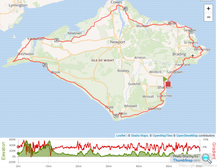
Full route here https://gb.mapometer.com/cycling/route_5123747.htm...
(ignore the start point which isn't quite right)
I have a road bike, so am trying to plan a route that avoids unpaved tracks or gravel paths. At the same time, I want to visit as much of the coast as possible. This is about sight seeing and ticking off a bucket list item, rather than maximum speed. Ice cream vans will be regular stopping points.
Any Isle of Wight regulars here able to offer advice or suggestions?
Full route here https://gb.mapometer.com/cycling/route_5123747.htm...
(ignore the start point which isn't quite right)
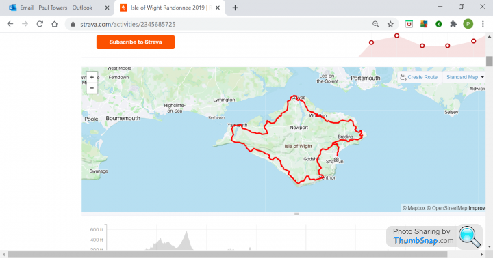
I've done the Randonnee for the last 2 years and absolutely loved it. Gutted it was cancelled this year! Of course, that route doesn't strictly follow the coastline, but, the roads are generally very quiet ones and it doesn't do any gravel tracks (apart from the bit to Yarmouth from Freshwater), but I did the road part of that too. You'll have a great time. I love the military road section!
Excellent, congrats on doing it 28 years later !!!!! Ferries all running again I think so should be a great trip...........
There's a round island route, clockwise or anti clockwise, pretty much follows the route you have there. There's either a blue sign with a white bike or a white sign with a blue bike, one for clockwise and one for anti clockwise, I just can't remember which way round it is but someone will be along shortly to advise, or Google will tell you !
I always do anti clockwise......not sure why, it just puts me around Cowes etc for a long lunch and a beer or two. The biggest hills are in the south so I like to get those cracked off earlier.............
Otherwise, lots of stop off points for refreshments wherever you want. I do it in a day...... from Somerset........... Drive down, early ish ferry, make the day of it and drive back in the evening...... perfect in good weather !
Road surfaces not great, especially up north
SomersetWestie said:
Excellent, congrats on doing it 28 years later !!!!! Ferries all running again I think so should be a great trip...........
There's a round island route, clockwise or anti clockwise, pretty much follows the route you have there. There's either a blue sign with a white bike or a white sign with a blue bike, one for clockwise and one for anti clockwise, I just can't remember which way round it is but someone will be along shortly to advise, or Google will tell you !
I always do anti clockwise......not sure why, it just puts me around Cowes etc for a long lunch and a beer or two. The biggest hills are in the south so I like to get those cracked off earlier.............
Otherwise, lots of stop off points for refreshments wherever you want. I do it in a day...... from Somerset........... Drive down, early ish ferry, make the day of it and drive back in the evening...... perfect in good weather !
Road surfaces not great, especially up north
That's the Randonnee route, but, to be fair it does miss a fair bit of the coastline out which the route above doesn't. It deviates quite a bit off the military road and doesn't do Sandown or Shanklin for example. There's a round island route, clockwise or anti clockwise, pretty much follows the route you have there. There's either a blue sign with a white bike or a white sign with a blue bike, one for clockwise and one for anti clockwise, I just can't remember which way round it is but someone will be along shortly to advise, or Google will tell you !
I always do anti clockwise......not sure why, it just puts me around Cowes etc for a long lunch and a beer or two. The biggest hills are in the south so I like to get those cracked off earlier.............
Otherwise, lots of stop off points for refreshments wherever you want. I do it in a day...... from Somerset........... Drive down, early ish ferry, make the day of it and drive back in the evening...... perfect in good weather !
Road surfaces not great, especially up north
I have done this a fair few times.
As others have said, it is reasonably straightforward to cycle around keeping to metal roads.
We tend to go anti-clockwise as you get a rain wind along military road at the bottom of the island and some of the ‘fun’ hills!
You have to drop down to the cafe at the bottom of Ventnor so you get the full experience of your cake making a ‘reappearance’ up the steep hill and then the long haul over to Shanklin / Sandown.
As previouly said there is a cycle route follow the blue signs, it comes past our place in Yafford and takes you away from the Military Road for a while which is quite nice in the summer because of traffic but it is also theMilly is the Islands racetrack for fast cars and motorbikes. If you want decent places to stop and eat Chessell Pottery Cafe which is run by lycralovers and Piano Cafe at Freshwater Bay. Southwest side will be much quieter. The road condtion is very good as nearly all of them have been resufaced in the last 7 years. Cycletrack from Sandown to Cowes is pretty level and has a decent cafe called Peddlars at Newchurch. My kids are massively into cycling and nipper rides for the local team so if you have any questions feel free to ask. He has been down most routes manytimes i think he did 5000 miles last year.
junglie said:
I have done this a fair few times.
As others have said, it is reasonably straightforward to cycle around keeping to metal roads.
We tend to go anti-clockwise as you get a rain wind along military road at the bottom of the island and some of the ‘fun’ hills!
You have to drop down to the cafe at the bottom of Ventnor so you get the full experience of your cake making a ‘reappearance’ up the steep hill and then the long haul over to Shanklin / Sandown.
Definitely this............... Drop into Ventnor and enjoy the climb out !!!! As others have said, you can deviate off whenever you like and rejoin if you want to go to a particular beach or bay........that's the fun of it As others have said, it is reasonably straightforward to cycle around keeping to metal roads.
We tend to go anti-clockwise as you get a rain wind along military road at the bottom of the island and some of the ‘fun’ hills!
You have to drop down to the cafe at the bottom of Ventnor so you get the full experience of your cake making a ‘reappearance’ up the steep hill and then the long haul over to Shanklin / Sandown.
. Just follow the signs all the way, no need for a map or GPS !SomersetWestie said:
no need for a map or GPS !
No no no no no no. I've just ordered myself a Wahoo Roam 
Thanks everyone. There's some things to think about above.
I'm starting from a Shanklin AirBnB, so planning on clockwise to get the big hills out of the way at the start.
Lots of people, including the Randonnee, seem to avoid the road south of Shanklin to Ventnor. Is it as bad as some of the gradient maps suggest?
alock said:
SomersetWestie said:
no need for a map or GPS !
No no no no no no. I've just ordered myself a Wahoo Roam Thanks everyone. There's some things to think about above.
I'm starting from a Shanklin AirBnB, so planning on clockwise to get the big hills out of the way at the start.
Lots of people, including the Randonnee, seem to avoid the road south of Shanklin to Ventnor. Is it as bad as some of the gradient maps suggest?
alock said:
No no no no no no. I've just ordered myself a Wahoo Roam
Thanks everyone. There's some things to think about above.
I'm starting from a Shanklin AirBnB, so planning on clockwise to get the big hills out of the way at the start.
Lots of people, including the Randonnee, seem to avoid the road south of Shanklin to Ventnor. Is it as bad as some of the gradient maps suggest?
Well that will come in useful anyway and will give you the chance to get used to using it while you plan the next adventure !!!!Thanks everyone. There's some things to think about above.
I'm starting from a Shanklin AirBnB, so planning on clockwise to get the big hills out of the way at the start.
Lots of people, including the Randonnee, seem to avoid the road south of Shanklin to Ventnor. Is it as bad as some of the gradient maps suggest?
Just checked back on Strava on the last anti clockwise one I did...........that was 68 miles and 5,000 feet of climbing by doing the little diversions

SomersetWestie said:
junglie said:
I have done this a fair few times.
As others have said, it is reasonably straightforward to cycle around keeping to metal roads.
We tend to go anti-clockwise as you get a rain wind along military road at the bottom of the island and some of the ‘fun’ hills!
You have to drop down to the cafe at the bottom of Ventnor so you get the full experience of your cake making a ‘reappearance’ up the steep hill and then the long haul over to Shanklin / Sandown.
Definitely this............... Drop into Ventnor and enjoy the climb out !!!! As others have said, you can deviate off whenever you like and rejoin if you want to go to a particular beach or bay........that's the fun of it As others have said, it is reasonably straightforward to cycle around keeping to metal roads.
We tend to go anti-clockwise as you get a rain wind along military road at the bottom of the island and some of the ‘fun’ hills!
You have to drop down to the cafe at the bottom of Ventnor so you get the full experience of your cake making a ‘reappearance’ up the steep hill and then the long haul over to Shanklin / Sandown.
. Just follow the signs all the way, no need for a map or GPS !alock said:
When I was 15, a friend and I had a plan to cycle around the Isle of Wight which never quite happened. It's now 28 years later and I'm finally going in a few weeks.
I have a road bike, so am trying to plan a route that avoids unpaved tracks or gravel paths. At the same time, I want to visit as much of the coast as possible. This is about sight seeing and ticking off a bucket list item, rather than maximum speed. Ice cream vans will be regular stopping points.
Any Isle of Wight regulars here able to offer advice or suggestions?
Full route here https://gb.mapometer.com/cycling/route_5123747.htm...
(ignore the start point which isn't quite right)
Is the bit from Ventnor to Niton open for cyclists? I know it's been closed to cars due to a landslide some years back, but wasn't sure if you can pedal along it okay?I have a road bike, so am trying to plan a route that avoids unpaved tracks or gravel paths. At the same time, I want to visit as much of the coast as possible. This is about sight seeing and ticking off a bucket list item, rather than maximum speed. Ice cream vans will be regular stopping points.
Any Isle of Wight regulars here able to offer advice or suggestions?
Full route here https://gb.mapometer.com/cycling/route_5123747.htm...
(ignore the start point which isn't quite right)
The Island is a hilly old place....particularly that southern half - not a bad idea getting it out of the way first!
mikeiow said:
Is the bit from Ventnor to Niton open for cyclists? I know it's been closed to cars due to a landslide some years back, but wasn't sure if you can pedal along it okay?
The Island is a hilly old place....particularly that southern half - not a bad idea getting it out of the way first!
The bit that goes straight up military road has been out for ages, hence the modified route for the Randonee over the past few years. It uses most of military road, without the dodgy bit.The Island is a hilly old place....particularly that southern half - not a bad idea getting it out of the way first!
Resurrecting this, I'm riding the island on Thursday from Yarmouth. Due to last minute ferry bookings I'll have about 5 hours so I'm riding to Newport then Wootton Bridge (chopping the top off) otherwise I'd need to push pretty hard to do the whole route in time, and not leave any time to enjoy it. (I'll come back in September and redo it properly).
Main question - are there any easy places I can refill water bottles without leaving the bike? I'll take a cheap lock just in case, but if I can plan ahead that would be great.
Main question - are there any easy places I can refill water bottles without leaving the bike? I'll take a cheap lock just in case, but if I can plan ahead that would be great.
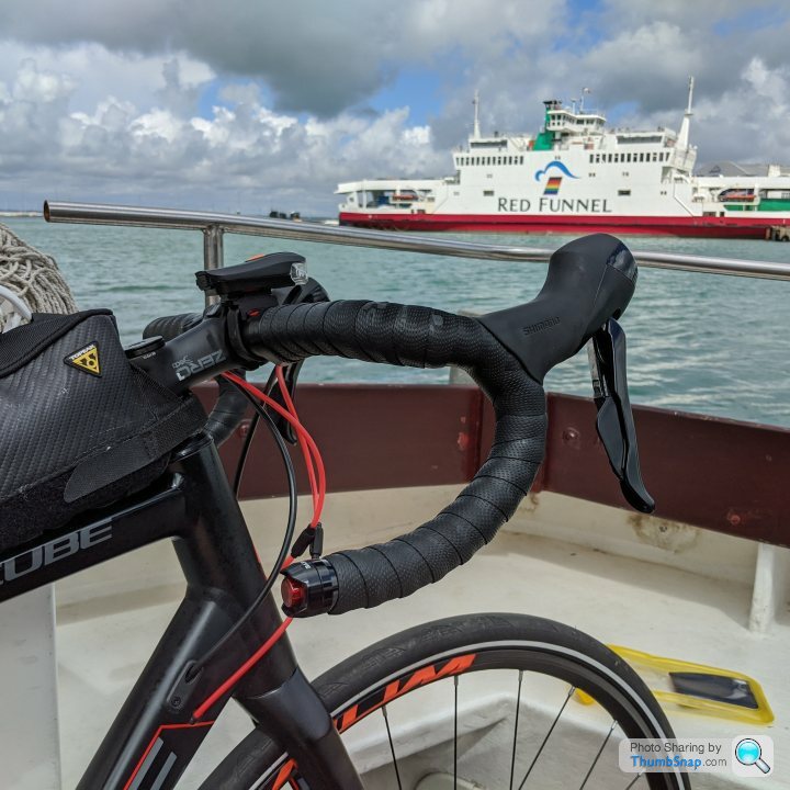
Done yesterday
https://strava.app.link/wEy6xNxu48
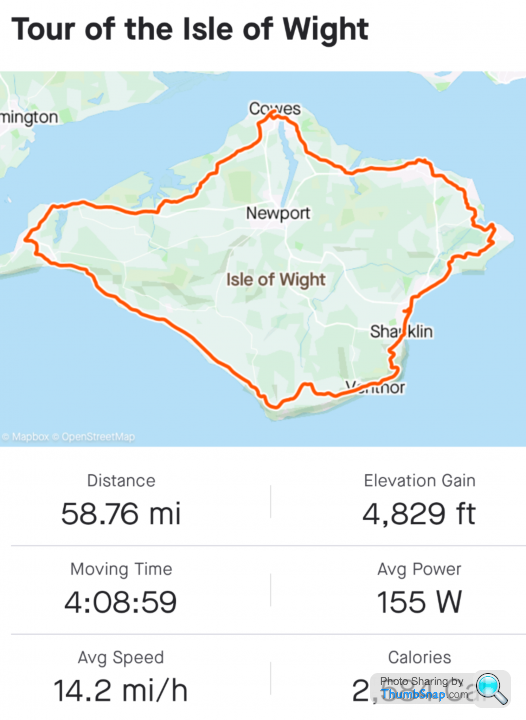
I was very grateful for my 34/32 lowest gear on several climbs, especially Shanklin to Ventnor. A 34/34 would have been even better.
https://strava.app.link/wEy6xNxu48
I was very grateful for my 34/32 lowest gear on several climbs, especially Shanklin to Ventnor. A 34/34 would have been even better.
Gareth79 said:
Main question - are there any easy places I can refill water bottles without leaving the bike? I'll take a cheap lock just in case, but if I can plan ahead that would be great.
I bought several bottles in the little cafe by the Cowes floating bridge, and an ice cream hut in sanddown. Both times my bike was within 2 metres and in full sight.Gassing Station | Pedal Powered | Top of Page | What's New | My Stuff