XC route mapping - caught between a rock and a hard place?
Discussion


How to find good routes for XC riding?
Long been a roadie but recently lost the passion for dodging close passing vehicles.
I’m a man of a certain age so I’ve taken to xc riding, bridleways, fire roads, that sort of thing.
I now have a rigid 29er and loving going out riding cross country - I guess we would call it gravel in the US.
Trouble is, how to find good routes that don’t get too technical or end up unsociably taking you down narrow public foothpaths.
Part of the fun is obviously exploring but sometimes you just want to follow a given route.
Explorer OS maps are great but not exactly convenient to keep checking one of those at every turn.
Any help to find a good way to find routes and then navigate by them would be appreciated, ta.
alolympic said:
How to find good routes for XC riding?
Long been a roadie but recently lost the passion for dodging close passing vehicles.
I’m a man of a certain age so I’ve taken to xc riding, bridleways, fire roads, that sort of thing.
I now have a rigid 29er and loving going out riding cross country - I guess we would call it gravel in the US.
Trouble is, how to find good routes that don’t get too technical or end up unsociably taking you down narrow public foothpaths.
Part of the fun is obviously exploring but sometimes you just want to follow a given route.
Explorer OS maps are great but not exactly convenient to keep checking one of those at every turn.
Any help to find a good way to find routes and then navigate by them would be appreciated, ta.
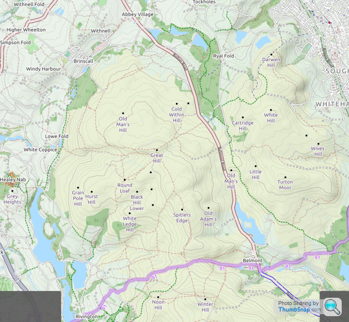
Where do you live? The OpenCycleMap posted is a good start as is Strava Segment explorer. I find google maps using a combination of satellite view and street view to be really useful at identifying paths and bridleways that look rideable. The problem with relying on the opencycle map is that you will potentially miss lots of good trails. Here are my local trails I did 40 miles of XC riding around here on Sat morning yet none of the trails are marked as cycle trails on the map.Long been a roadie but recently lost the passion for dodging close passing vehicles.
I’m a man of a certain age so I’ve taken to xc riding, bridleways, fire roads, that sort of thing.
I now have a rigid 29er and loving going out riding cross country - I guess we would call it gravel in the US.
Trouble is, how to find good routes that don’t get too technical or end up unsociably taking you down narrow public foothpaths.
Part of the fun is obviously exploring but sometimes you just want to follow a given route.
Explorer OS maps are great but not exactly convenient to keep checking one of those at every turn.
Any help to find a good way to find routes and then navigate by them would be appreciated, ta.
https://ridewithgps.com/ and flick between the OSM cycle overlay and the RWGPS overlay. If I recall, green dotted lines on the OSM Cycle overlay are bridleways and reddy brown dotted lines are footpaths
lufbramatt said:
Komoot and Trailforks are worth a look. Komoot has a huge library of user generated routes to help get an idea of where to go as well as the mapping aspect. Trailforks is more descriptions of individual trails but still useful.
Trailforks is pretty good; requires a bit of research and trial and error but the results are very good, especially on areas that are difficult to understand due to geography. Some people (like me) connect it to Strava, so you can explore rides in the same way of Strava and check for comments and updated descriptions of sections of the trails.Gassing Station | Pedal Powered | Top of Page | What's New | My Stuff