Cycle route from Ripon area to Grasmere, Lake District
Discussion


Hi,
I'm looking at cycling from east of Ripon to Grasmere in the Lakes this Sunday morning to meet family for a few days. I have not cycled this route before so would welcome any route advice or places / roads to consider or avoid etc.
Google maps is giving me a route that I will use as a starting point to work from and right now I think I will head out to Masham, Middleham and then towards Bainbridge, and onto Sedbergh, but beyond there I am unsure and would like to avoid fast A roads and prefer to stick to quieter roads if I can. That said I want to keep the mileage and climbing down where I can as the route is likely to be 90 miles and I need to get there with some life left in me !
As an aside - I have looked at the Way of the Roses route but that is going across too far south for me.
All suggestions on route options greatly appreciated.
Thanks
If you can be arsed, what I've done in the past is look in the general area for Strava segments, choose one, then have a look at the leaderboard. Choose a rider at random, and check out the rest of his ride...
Example.
I found a segment near Sedburgh called Scotch Jeans desent (that is the Strava segment name, not my spelling...).
https://www.strava.com/segments/3554738
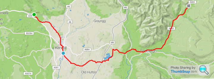
Randomly chose the fourth place rider, a Mr Joss Livesey, then had a look at his route. I know he's going West to East, but it does give you a possible route from Sedburgh to Staveley, one which appears all but to avoid the busy routes in and out of Kendal...
https://www.strava.com/activities/1198126122/overv...
Do the same for any other bits you are unsure of, this way you can usually ride the routes that the locals use, rather than being stuck on the main roads...
Example.
I found a segment near Sedburgh called Scotch Jeans desent (that is the Strava segment name, not my spelling...).
https://www.strava.com/segments/3554738
Randomly chose the fourth place rider, a Mr Joss Livesey, then had a look at his route. I know he's going West to East, but it does give you a possible route from Sedburgh to Staveley, one which appears all but to avoid the busy routes in and out of Kendal...
https://www.strava.com/activities/1198126122/overv...
Do the same for any other bits you are unsure of, this way you can usually ride the routes that the locals use, rather than being stuck on the main roads...
Try this...
https://www.google.co.uk/maps/dir/Ripon/Grasmere,+...
...as a starting point to refine your route.
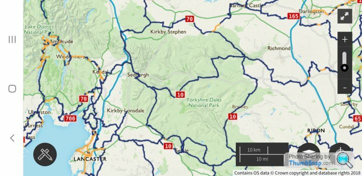
I was posted to Ripon for three years, and that was my favourite route out of the city. Grewelthorpe is lovely, over into Wensleydale, Castle Bolton (public toilets near the castle if you need to plan for that) and then on to Askrigg and Hawe. Beyond that, my knowledge runs out as I was always looping back to Ripon, often well before Hawe. It's beautiful scenery, but give yourself plenty of time, as it really is hilly (although I was on an old steel bike running 53/39 x 14-23 gears back then, like a fool). Or wiggle through the narrower roads from East Witton to Aysgarth. It can be bleak, and even in 'tourist season' you can go long periods without seeing another soul, so make sure you're good for spares, tools, and a decent pump, with plenty to eat and drink, and top up when the opportunity presents, not when you've run out of food/drink. I'm trying to remember one particular road that was spectacular for having the railway cross it many times, high above on bridges and short sections of viaduct, but i cannot for the life of me recall the name of the village that leads to it. It may be worth a detour south between Hawe and Cowgill, too, to get a view of the Ribblehead Viaduct, and the three peaks of Whernside, Ingleborough, and Pen-y-ghent.
Oh, and spend some time with Google Maps and check out the roads on Streetview too, as you shouldn't trust the 20-year-old memories of some random bloke on the internet...
https://www.google.co.uk/maps/dir/Ripon/Grasmere,+...
...as a starting point to refine your route.
I was posted to Ripon for three years, and that was my favourite route out of the city. Grewelthorpe is lovely, over into Wensleydale, Castle Bolton (public toilets near the castle if you need to plan for that) and then on to Askrigg and Hawe. Beyond that, my knowledge runs out as I was always looping back to Ripon, often well before Hawe. It's beautiful scenery, but give yourself plenty of time, as it really is hilly (although I was on an old steel bike running 53/39 x 14-23 gears back then, like a fool). Or wiggle through the narrower roads from East Witton to Aysgarth. It can be bleak, and even in 'tourist season' you can go long periods without seeing another soul, so make sure you're good for spares, tools, and a decent pump, with plenty to eat and drink, and top up when the opportunity presents, not when you've run out of food/drink. I'm trying to remember one particular road that was spectacular for having the railway cross it many times, high above on bridges and short sections of viaduct, but i cannot for the life of me recall the name of the village that leads to it. It may be worth a detour south between Hawe and Cowgill, too, to get a view of the Ribblehead Viaduct, and the three peaks of Whernside, Ingleborough, and Pen-y-ghent.
Oh, and spend some time with Google Maps and check out the roads on Streetview too, as you shouldn't trust the 20-year-old memories of some random bloke on the internet...
Johnny said:
Good point,well made 
I don't know if the OP has the OS subscription £20 a year which is excellent value, but they emailed the other day to say they had overlayed the sustrans layer onto the OS map so may be handy for future reference.The os premium app (£20pa) seems to have a whole variety of walking and cycling additions as well added by users.
https://osmaps.ordnancesurvey.co.uk/
Just wrote lengthy response and then safari lost it before I could submit.
Anyway. Condensed 2nd take.
I rode on sun morning. Avoided rain.
Suggestion to use strava helped.
I plotted route via leyburn, to castle Bolton and towards Hawes and then Sedbergh. Then back lanes avoiding Kendal before into Ambleside on a591.
Stored route on Garmin. Then followed cycle paths off a591 near to lakes which added hills and miles.
Final route was 100 miles and 6,000 ft of climbing. I took it nice and steady. No racing. Took just over 7 hrs.
Thanks all.
Gassing Station | Pedal Powered | Top of Page | What's New | My Stuff