What’s the speed limit on this road?
Discussion
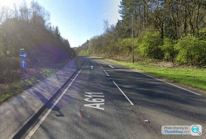
Currently having a discussion on Twitter with a group of Advanced Motorcyclists and drivers about the limit on the road in the image below, all we can agree on so far is it’s abit ambiguous and open to interpretation!
For years I’ve always assumed the NSL Southbound section of this road was a 70 limit.

I assumed that with both roads north and south being the A611, it was a dual carriageway (There is a sign stating this further back) with the large forested area being the “central barrier/reservation”
That was until a few years ago at an IAM meeting with examiners in attendance the question came up and all 3 (1 Response Paramedic and 2 Road Policing Officers) were positive it was a 60 due to the lack of barrier/reservation between the carriageways. When I pointed out I believed the large forested area was the divide, the response was simply that would be a judgement for a magistrate to make.
So what would everyone else’s thoughts be on this particular section? As was pointed out by someone on Twitter, there is no minimum or maximum stated width for a barrier/reservation.
For years I’ve always assumed the NSL Southbound section of this road was a 70 limit.

I assumed that with both roads north and south being the A611, it was a dual carriageway (There is a sign stating this further back) with the large forested area being the “central barrier/reservation”
That was until a few years ago at an IAM meeting with examiners in attendance the question came up and all 3 (1 Response Paramedic and 2 Road Policing Officers) were positive it was a 60 due to the lack of barrier/reservation between the carriageways. When I pointed out I believed the large forested area was the divide, the response was simply that would be a judgement for a magistrate to make.
So what would everyone else’s thoughts be on this particular section? As was pointed out by someone on Twitter, there is no minimum or maximum stated width for a barrier/reservation.
N/bound is 50mph as shown here;
https://www.google.co.uk/maps/@53.0560587,-1.22982...
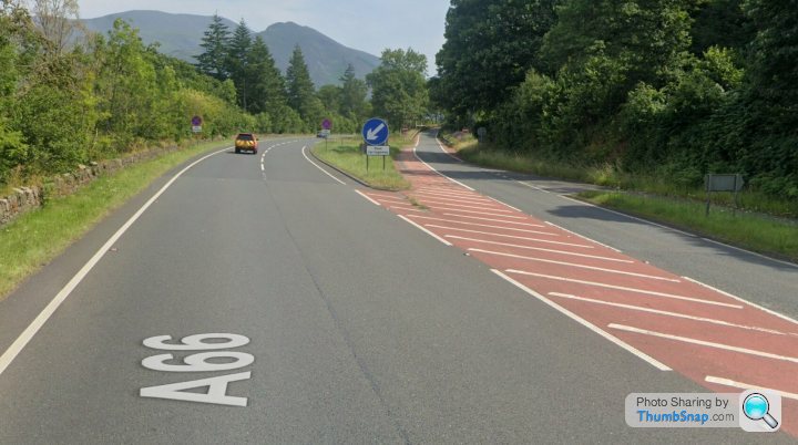
S/bound is NSL (i.e. 70mph for cars, etc), it's no different to the A66 near Keswick, which is 50/70 depending on direction (N.B. the 50mph limit W/bound is enforced by Av. speed cameras).
https://www.google.co.uk/maps/place/A611/@54.64734...
https://www.google.co.uk/maps/@53.0560587,-1.22982...
S/bound is NSL (i.e. 70mph for cars, etc), it's no different to the A66 near Keswick, which is 50/70 depending on direction (N.B. the 50mph limit W/bound is enforced by Av. speed cameras).
https://www.google.co.uk/maps/place/A611/@54.64734...
Mammasaid said:
N/bound is 50mph as shown here;
https://www.google.co.uk/maps/@53.0560587,-1.22982...
S/bound is NSL (i.e. 70mph for cars, etc), it's no different to the A66 near Keswick, which is 50/70 depending on direction (N.B. the 50mph limit W/bound is enforced by Av. speed cameras).
https://www.google.co.uk/maps/place/A611/@54.64734...
The Northbound became a 50 a few years ago (2020 I believe) after a very nasty accident with a group of teens in a car going far too fast and spinning off into the trees. I do agree with that section being a 50, it doesn’t look bad from a map but is twisty with off cambers on several bends. One of Nottinghamshires few “Actually it should be a 50” roads!https://www.google.co.uk/maps/@53.0560587,-1.22982...
S/bound is NSL (i.e. 70mph for cars, etc), it's no different to the A66 near Keswick, which is 50/70 depending on direction (N.B. the 50mph limit W/bound is enforced by Av. speed cameras).
https://www.google.co.uk/maps/place/A611/@54.64734...
The southbound section is wide open with good visibility and a smooth surface.
I think the issue lays with the “barrier/reservation”, would that large wooded area be classed as the barrier? I always assumed yes but 3 people with more experience and training than me said no but can’t seem to find any specifics to back that up so just wondered what others interpretation might be.
2 sMoKiN bArReLs said:
A dual carriageway doesn't need a barrier, just a median?
That’s what I thought and it’s supported by the Road Traffic Regulation Act.“dual-carriageway road” means a road part of which consists of a central reservation to separate a carriageway to be used by vehicles proceeding in one direction from a carriageway to be used by vehicles proceeding in the opposite direction;”
I just wonder how they define a “Central Reservation”? A length of rope or as with the case of the A611, a large woodland area! Let’s be fair, you’d have to be in a plane to have a head on with the other carriageway!
Mammasaid said:
N/bound is 50mph as shown here;
https://www.google.co.uk/maps/@53.0560587,-1.22982...
S/bound is NSL (i.e. 70mph for cars, etc), it's no different to the A66 near Keswick, which is 50/70 depending on direction (N.B. the 50mph limit W/bound is enforced by Av. speed cameras).
https://www.google.co.uk/maps/place/A611/@54.64734...
The Keswick example there is a barrier between the carriageways, on both sides of the woods, so there are two barriers and the woods. The OPs example there are no barriers, just the woods, so it is different.https://www.google.co.uk/maps/@53.0560587,-1.22982...
S/bound is NSL (i.e. 70mph for cars, etc), it's no different to the A66 near Keswick, which is 50/70 depending on direction (N.B. the 50mph limit W/bound is enforced by Av. speed cameras).
https://www.google.co.uk/maps/place/A611/@54.64734...
The reasons it's 50 in one direction is that the barrier above the drop failed a structural examination and the Council elected not to fix it properly, based on a mix of cost and the fact that that bit of road was epic and they hate drivers.
The point that the separation is adequate to be described as a central reservation would be a question of reasonableness. It's pretty clear that there is a central reservation in the middle, but it may be difficult to say exactly where the speed limit changes between 60 and 70.
The aspect I'm not clear on is that there is clearly public access to that woodland, you can see the paths all over. Is it sufficiently reserved to allow for 70mph traffic, or should the lower limit remain in place due to the risk of conflict with the general public rather than other vehicles? Or is it simply not reserved, so not a central reservation?
From the point of view of separation, that's indisputably a dual carriageway. The 1 Response Paramedic and 2 Road Policing Officers are answering the wrong question, in effect 
My usual example to use when making the point about this in RoSPA sessions is the Llywel to Tirabad road. Where it is most obviously marked a dual carriageway, because of the existence of physical separation. Important to note here that there's no armco or other such traffic barrier.
https://www.google.com/maps/@51.9574758,-3.6473783...
Where this one gets a bit grey for me is that it's missing actual 'dual carriageway' signage. The importance of that is that's a legal requirement for the dual carriageway to exist. The only reason I can think of for this to be missing, is that it's so obvious! Given you can't even see the northbound carriageway at the point of entry onto the southbound section.
But there's also the fitting of continuing 'one way' signs along the section. Which leads me to think that they may have designed it, in effect, as a one-way section with two lanes. Which would therefore NOT be under national 70mph designation, but 60mph:

Suffice to say, if you need to go to these lengths to understand what's going on, they've not designed it very well. And they'd do well to just put some actual speed signage along the southbound stretch instead!

My usual example to use when making the point about this in RoSPA sessions is the Llywel to Tirabad road. Where it is most obviously marked a dual carriageway, because of the existence of physical separation. Important to note here that there's no armco or other such traffic barrier.
https://www.google.com/maps/@51.9574758,-3.6473783...
Where this one gets a bit grey for me is that it's missing actual 'dual carriageway' signage. The importance of that is that's a legal requirement for the dual carriageway to exist. The only reason I can think of for this to be missing, is that it's so obvious! Given you can't even see the northbound carriageway at the point of entry onto the southbound section.
But there's also the fitting of continuing 'one way' signs along the section. Which leads me to think that they may have designed it, in effect, as a one-way section with two lanes. Which would therefore NOT be under national 70mph designation, but 60mph:

Suffice to say, if you need to go to these lengths to understand what's going on, they've not designed it very well. And they'd do well to just put some actual speed signage along the southbound stretch instead!
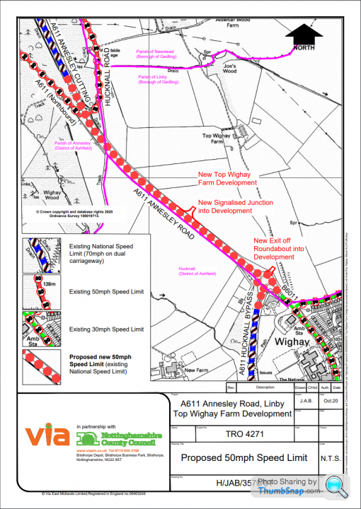
A little digging says that the limit S/bound is 70,
https://consult.nottinghamshire.gov.uk/traffic-reg...

https://consult.nottinghamshire.gov.uk/traffic-reg...

Standard plan key notwithstanding, the consultation letter does give some helpful information! I think we have our answer. Although they're still missing the dual carriageway signage at the start of the stretch, to make it official!

https://consult.nottinghamshire.gov.uk/traffic-reg...

https://consult.nottinghamshire.gov.uk/traffic-reg...
Edited by Wardy5 on Tuesday 10th October 11:51
Wardy5 said:
Standard plan key notwithstanding, the consultation letter does give some helpful information! I think we have our answer. Although they're still missing the dual carriageway signage at the start of the stretch, to make it official!

https://consult.nottinghamshire.gov.uk/traffic-reg...
When did they make the DC ahead sign mandatory?
https://consult.nottinghamshire.gov.uk/traffic-reg...
Edited by Wardy5 on Tuesday 10th October 11:51
It's not the 'ahead' signage I'm referring to, but the 'Dual Carriageway' sign. As is evident in the A66 Keswick section talked about above.

In terms of the mandatory nature, I was thinking of Traffic Signs Manual Chapter 4. Obviously that being backed up by The Traffic Signs Regulations and General Directions 2016. In hindsight it may be a 'should' not a 'must'.
My thinking being that there needs to be mandatory signage to indicate the change between national single carriageway and national dual carriageway, given there is a speed limit difference involved. Which, ironically, could lead to the exact question that this thread poses!
It would seem to be an issue the whole length of this southern section, seeing as I can't seem to find any 'end of dual carriageway' signage. So logic could dictate that if the end isn't marked, it may never have begun....

Edited by Wardy5 on Tuesday 10th October 13:11
Wardy5 said:
It's not the 'ahead' signage I'm referring to, but the 'Dual Carriageway' sign. As is evident in the A66 Keswick section talked about above.

In terms of the mandatory nature, I was thinking of Traffic Signs Manual Chapter 4. Obviously that being backed up by The Traffic Signs Regulations and General Directions 2016. In hindsight it may be a 'should' not a 'must'.
My thinking being that there needs to be mandatory signage to indicate the change between national single carriageway and national dual carriageway, given there is a speed limit difference involved. Which, ironically, could lead to the exact question that this thread poses!
It would seem to be an issue the whole length of this southern section, seeing as I can't seem to find any 'end of dual carriageway' signage. So logic could dictate that if the end isn't marked, it may never have begun....
I thought you were referring to the blue rectangular "dual carriageway ahead" - I've seen people say it must be present in previous discussions on what defines a DC. 
In terms of the mandatory nature, I was thinking of Traffic Signs Manual Chapter 4. Obviously that being backed up by The Traffic Signs Regulations and General Directions 2016. In hindsight it may be a 'should' not a 'must'.
My thinking being that there needs to be mandatory signage to indicate the change between national single carriageway and national dual carriageway, given there is a speed limit difference involved. Which, ironically, could lead to the exact question that this thread poses!
It would seem to be an issue the whole length of this southern section, seeing as I can't seem to find any 'end of dual carriageway' signage. So logic could dictate that if the end isn't marked, it may never have begun....

Edited by Wardy5 on Tuesday 10th October 13:11
Looking at the op road on Google I was surprised to see one way road signs on one side. Talking about traffic signs manuals, I've had a look at #3 and found this:
4.9.1. The “one‑way traffic” sign to diagram 652 (S9‑4‑5, see Figure 4‑30) may be used only to indicate the effect of a TRO which requires vehicles to proceed in one direction only. It should not be used to sign traffic along one carriageway of a dual carriageway road. However, where a rural dual carriageway comprises two one‑way roads (i.e. where there is non‑highway land between the two carriageways) each carriageway should be subject to a one‑way traffic order and signs to diagram 652 provided accordingly. The ahead arrow road marking to diagram 1038 (S11‑4‑20, see Chapter 5) may be used in conjunction with the “one‑way traffic” sign.
I think the road in the OP should be a "rural dual carriageway" which I'd never heard of. So one side is correctly signed as a one way street but the other side isn't?! If it was just a one way street I'd say nsl=60, but as they're still defining it as a (rural) dual carriageway, then nsl=70. Clear as mud.
Gassing Station | Advanced Driving | Top of Page | What's New | My Stuff


