Best Roads in Perth region SW-WA
Discussion
Hello folks,
I have some upcoming freetime and plan to spend it riding and driving around Perth and SW-WA (say within a days drive of Perth) and was looking for some recommendations of best sections of road other forum members have found. If this ends up being any use then it could become a wiki, I haven't found a Pistonheads favorite roads WA thread?
Obviously the standard; Indian ocean sunset drive for a metro area, Toodyay, Gin gin, Bindoon, York, Mundaring weir and 3 dams, Walpole, Jarrah Highway, Pinnicles etc etc is all well established. Is there anywhere extra special and little known about that people can recommend?
Lets say key considerations are:
Lack of other road users (i.e. lack of traffic, people and Plodders)
Elevation gain (some ups and downs, better than flat)
Number of bends in a section (twisty sections with elevation gain and undulations good)
Road surface quality (recently resurfaced, agricultural dirt on road etc)
Longevity of entertaining sections
Loopability (does it have a feasible drive out or end in a corrugated road, Not great for a bike)
Proximity to Perth (Not a huge factor but driving for several hrs across the nullarbor for 1hr of fun to have to drive back would not be preferable)
Any input from Westralians or people of knowledge most welcome
Edited by Hoopsuk on Wednesday 31st July 19:15
Back in the 90s I used to drive around the wheatbelt, mainly to go for a drive and see all the places that I had to look after at work. I left one afternoon at 2pm and ended up in Pingelly, Narrogin, Wickepin and Quariding. I got home at about 9pm only to find the front door wide open as I had not closed it! I arrived at Kelleberin another time looking for the airport only to realise I was actually in the middle of it! Likewise Wongan Hills. Remember driving through Gomalling and seeing a brand new Falcon EL GT in the showroom that had been there for about 18 months.
Roads, you have mentioned a lot of them. I used to avoid the main ones but keep to the tarmaced ones. A good map helped. The twisty bits were all in the hills. I would drive through the back of the hills to get to the wheatbelt so I had my fun then.
Roads, you have mentioned a lot of them. I used to avoid the main ones but keep to the tarmaced ones. A good map helped. The twisty bits were all in the hills. I would drive through the back of the hills to get to the wheatbelt so I had my fun then.
Ok, some fair tips but I am after specific roads, Probably in the hill country for some vertical relief. Does anyone have any knowledge around Harvey or inland roads from there. I once found a very enjoyable stretch down around pinjarra towards collie, Nanga road it was called but it was a little too narrow and twisty in some parts and ended with some corrugated sections.
Colonial said:
The one that leads to the airport so you can get away 
This, absolutely this.
I have two sons and their families living in Perth so get there pretty often and the roads are bats
 t boring but a lot admittedly have very good tarmac.
When they come here they cannot get over the fact that the place isn't flat, No.2 son drove the clubbie through the RNP which don't find inspiring at all and found it to be a brilliant driving experience.
Some interesting satirical points, but whilst we can't exactly compare it to alpine driving bliss, to say it is flat is a matter of perspective. 
Some facts for the uninformed:
The highest point in the darling range is Mt cooke at 582m. One can drive to a little under 400m asl on mt cooke and surrounding hills (They would be called mountains in the UK, defined as 1000ft in wales so 300m). Mt cooke is around 30 to 40km from Perth and 20Km from the coastal plain giving a near enough 400m elevation gain or 1300ft. Paved major roads such as the albany or great eastern highways see a 200m (650ft) gain within less than 15km from Perth metro.
If we venture a little further south to the Stirling range (3hr drive from Perth) we have stirling range drive which peaks at close to 500m snaking its way between 700m to 800m mountains with the 1099m 3606ft peak of bluff knoll to the east.
The Perth area has more rounded and weathered terrain than the classic mountains of the UK and Europe because it is some of the oldest continental crust on the planet. Sure its no where near as spectacular but I live in Australia and I don't fancy going back to Europe or North America every time I want a decent drive.
Now, to compare with the mother Island.
The highest mountain in the whole of england and wales is Snowdon at 1085m, the highest mountain in england is Scafell pike at 978m. You have to go to Scotland to find Mountains higher than those in the Perth region and even then, Ben nevis is only a little over 300m Higher than Bluff Knoll.
The highest road pass England is in the lake district at around 627m,The highest acknowledged pass in the UK is the Cairnwell at 670m taking you to Glenshee.
Within Australia, the highest Mont is Kosioskco at 2228m, with the highest road being the great alpine at 1840m. Whilst these are comparatively high and impressive roads, the vertical relief of what they offer is a little more telling, being on a plateau of 500m with some vertical gains on the switch backs of 700m it is by far the best relief type road Aus has to offer. Not exactly in the alpine class (in many ways) but better than SW-WA by a factor of 4 at least. But then this road is a 700km 7.5hr drive from Sydney and 370km, 4hr plus drive from Melbs, not exactly the stuff of day trip drives. Similarly, to find the sort of 200m to 400m relief we see in the Darling ranges 15km from Perth CBD, one has to drive 60 to 80km from Sydney CBD, still a day trip but further for the same sort of roads with alot more tedious traffic inbetween.
So, to revert to the matter of perspective: We may conclude the 'Flatness' of the Perth area is therefore comparable with some of the highest roads in the UK, none of which are particularly close to a metropolitan area containing well over 1 million people or indeed that close comparatively to the sea and an ocean plain. The flatness of the Perth area is also comparable to that of Sydney and/or other state capitals in Australia. Whilst the road density is greater leading to more roads, the population being far greater in both Europe and the eastern states means that the chance of finding a truly empty road is less than in WA.
If you live in the Alps, Rockies, Himilayas, Andes, Caucasus, Dolomites, Atlas, Urals etc then indeed, Perth is flat. If you live in the UK, particularly southern England its actually really rather mountainous by comparison. If you are from the eastern states, then the roads, terrain and relief are similar within a couple of hrs of the Main metropolitan areas. No doubt the 'best' roads in aus (by the definitions listed in the OP) are in the snowy mountain area, but I don't live there, I live in Perth.
Incidentally, the thread for perth bashing is here:
http://www.pistonheads.com/gassing/topic.asp?h=0&a...


Now, to get back on the topic of the thread, does anyone with informed true local knowledge have any road driving recommendations in the perth region SW-WA?


Some facts for the uninformed:
The highest point in the darling range is Mt cooke at 582m. One can drive to a little under 400m asl on mt cooke and surrounding hills (They would be called mountains in the UK, defined as 1000ft in wales so 300m). Mt cooke is around 30 to 40km from Perth and 20Km from the coastal plain giving a near enough 400m elevation gain or 1300ft. Paved major roads such as the albany or great eastern highways see a 200m (650ft) gain within less than 15km from Perth metro.
If we venture a little further south to the Stirling range (3hr drive from Perth) we have stirling range drive which peaks at close to 500m snaking its way between 700m to 800m mountains with the 1099m 3606ft peak of bluff knoll to the east.
The Perth area has more rounded and weathered terrain than the classic mountains of the UK and Europe because it is some of the oldest continental crust on the planet. Sure its no where near as spectacular but I live in Australia and I don't fancy going back to Europe or North America every time I want a decent drive.
Now, to compare with the mother Island.
The highest mountain in the whole of england and wales is Snowdon at 1085m, the highest mountain in england is Scafell pike at 978m. You have to go to Scotland to find Mountains higher than those in the Perth region and even then, Ben nevis is only a little over 300m Higher than Bluff Knoll.
The highest road pass England is in the lake district at around 627m,The highest acknowledged pass in the UK is the Cairnwell at 670m taking you to Glenshee.

Within Australia, the highest Mont is Kosioskco at 2228m, with the highest road being the great alpine at 1840m. Whilst these are comparatively high and impressive roads, the vertical relief of what they offer is a little more telling, being on a plateau of 500m with some vertical gains on the switch backs of 700m it is by far the best relief type road Aus has to offer. Not exactly in the alpine class (in many ways) but better than SW-WA by a factor of 4 at least. But then this road is a 700km 7.5hr drive from Sydney and 370km, 4hr plus drive from Melbs, not exactly the stuff of day trip drives. Similarly, to find the sort of 200m to 400m relief we see in the Darling ranges 15km from Perth CBD, one has to drive 60 to 80km from Sydney CBD, still a day trip but further for the same sort of roads with alot more tedious traffic inbetween.
So, to revert to the matter of perspective: We may conclude the 'Flatness' of the Perth area is therefore comparable with some of the highest roads in the UK, none of which are particularly close to a metropolitan area containing well over 1 million people or indeed that close comparatively to the sea and an ocean plain. The flatness of the Perth area is also comparable to that of Sydney and/or other state capitals in Australia. Whilst the road density is greater leading to more roads, the population being far greater in both Europe and the eastern states means that the chance of finding a truly empty road is less than in WA.
If you live in the Alps, Rockies, Himilayas, Andes, Caucasus, Dolomites, Atlas, Urals etc then indeed, Perth is flat. If you live in the UK, particularly southern England its actually really rather mountainous by comparison. If you are from the eastern states, then the roads, terrain and relief are similar within a couple of hrs of the Main metropolitan areas. No doubt the 'best' roads in aus (by the definitions listed in the OP) are in the snowy mountain area, but I don't live there, I live in Perth.
Incidentally, the thread for perth bashing is here:
http://www.pistonheads.com/gassing/topic.asp?h=0&a...


Now, to get back on the topic of the thread, does anyone with informed true local knowledge have any road driving recommendations in the perth region SW-WA?

Edited by Hoopsuk on Thursday 8th August 14:49
papahet said:
I think your OP has captured most of them...Can't say as I know of anything that is off the known roads. Might just be a case of getting your googlefu earthfu on and seeing if you can spot a road to take.
I'm back there in a couple of weeks so if there is no suggestions by then I will go with the Google-drive and find something good. I'll revisit Nanga and do a write up on here of anything good I find.madazrx7 said:
If we can get the bloody curry thread happening you can all drive to my place which is approx 300M ASL :thumbsup: and if you go the long way you can arrive via MWR as well
This is my favorite road for a quick ride around Perth, the old Toodyay road with the pioneers trail is a close 2nd and has less traffic. Unfortunately, as you said in other posts MWR is a bit patrolled and (although not exactly brimming with traffic,) its a bit too easy to find so gets cars on it, both potentially hampering the driving joy.I'll be riding around your way a bit when back in a couple of weeks. If the PH-WA hoon happens in the next month I'll be in.
Ok, So I managed to re-drive a few of my favorites and will post the details shortly. I'm still open to sensible recommendations and will test any out when I am next in Perth in December. This time round I only managed short hops as far south as Harvey and as far north as Gingin.
Forgot to bring the snaps I took of key start and finish points offshore with me but will attempt to update as it develops.
Forgot to bring the snaps I took of key start and finish points offshore with me but will attempt to update as it develops.
Hoopsuk said:
Ok, So I managed to re-drive a few of my favorites and will post the details shortly. I'm still open to sensible recommendations and will test any out when I am next in Perth in December. This time round I only managed short hops as far south as Harvey and as far north as Gingin.
Forgot to bring the snaps I took of key start and finish points offshore with me but will attempt to update as it develops.
If you can point me to an easy to use route builder, I can map a few for you.Forgot to bring the snaps I took of key start and finish points offshore with me but will attempt to update as it develops.
I'm talking just clicking a mouse at points along the route and it does the rest. I cant remember the road names you see...
Reardy Mister said:
If you can point me to an easy to use route builder, I can map a few for you.
I'm talking just clicking a mouse at points along the route and it does the rest. I cant remember the road names you see...
Google maps is pretty good for that, click on get directions then simply right click the places on the map to add way points to a route.I'm talking just clicking a mouse at points along the route and it does the rest. I cant remember the road names you see...
Ok, so should say that profiles extracted and distances given in the following are approximate and rounded. Pictures will be added to each route when I get my cameras SD card back and sorted. Starting off with my favourite then will work through some more of the established ones. I should point out I drove up Mt Solus, part of the unpaved pioneer trail and other such unpaved routes in the research of the following posts. I have eliminated anything that got a bit too unpaved for long sections such as the harvey-Qunindanning rd and south Nanga, Mt Solus etc.
Edited by Hoopsuk on Wednesday 11th September 20:50
Wanga up Nanga
Route Statistics-
| Start Distance From Perth (km) | 110 (or 60km) |
| Route Distance | 67km |
| Start Elevation (m) | 45 |
| Total Climb (m) | 952 |
| Total descent (m) | -930 |
| Max elevation (m) | 359 |
| End elevation (m) | 62 |
| No of bends | 77 |
| Max gradient | 11% |
| Surface | Sealed |
| Traffic | Very Low |
| Max speed limit | 110kmh |
| Speed camera Likelyhood | Low to Moderate |
Directions-
- Start in Waroona
- Take Thatchers st to Nanga Brook Rd
- Follow Nanga Brook rd for approx. 20km to junction with Nanga rd
- Follow Naga rd North (South is unpaved) to Dwellingup (Approx 20km)
- Take Del Park Rd from central dwellinup North (Approx 26km)
- Finish at Junction with SW highway 60km from Perth

Note- Vertical axis in m, Horizontal axis in Km
Pictures from Route-
Map of Route
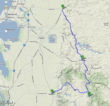
Verdict
One of my favorite roads close to Perth, National speed limit sections, plenty of terrain variation and relatively empty roads make for a great drive. Has some nice hairpins at some of the steeper sections and snakes in and out of small valleys. Be aware of cyclists and other groups who may use this road particularly in the summer months and holidays. Del Park road has a bit more traffic including some haulage with more restrictive speed limits.
Edited by Hoopsuk on Wednesday 11th September 21:34
206 Loop
Route Statistics-
| Start Distance From Perth (km) | 55 |
| Route Distance | 34km |
| Start Elevation (m) | 45 |
| Total Climb (m) | 534 |
| Total descent (m) | -509 |
| Max elevation (m) | 318 |
| End elevation (m) | 60 |
| No of bends | 48 |
| Max gradient | 6% |
| Surface | Sealed |
| Traffic | Moderate to High (Depending on season) |
| Max speed limit | 90kmh |
| Speed camera Likelyhood | Moderate |
Directions-
- Start Watkins rd Nature reserve
- Cross SW Highway
- Take Jarrahdale Rd
- Turn Right Kingsbury drive rt 206 follow for 23km (approx)
- Finish at Junction with SW highway 60km from Perth

Note- Vertical axis in m, Horizontal axis in Km
Pictures from Route-
Map of Route

Verdict-
A pleasant drive past the serpentine but prohibitive speed limits slow things down somewhat. Not as pedestrian as the MWR but potentially a better drive. Holidays and weekends can see road traffic soar. Best driven in midweek or during rainy weather. Nice and close to Perth.
Edited by Hoopsuk on Wednesday 11th September 21:38
Mundaring Weir Circuit
Route Statistics-
| Start Distance From Perth (km) | 23 |
| Route Distance | 40km |
| Start Elevation (m) | 65 |
| Total Climb (m) | 790 |
| Total descent (m) | -795 |
| Max elevation (m) | 310 |
| End elevation (m) | 60 |
| No of bends | 78 |
| Max gradient | 9% |
| Surface | Sealed |
| Traffic | Moderate to High (Depending on day) |
| Max speed limit | 80kmh |
| Speed camera Likelyhood | Moderate to high |
Directions-
- Start Maida Vale on goosebury hill rd and kalamunda road
- Turn left onto Watsonia road after 750m turn right onto ridge hill rd left then right onto scott St.
- In helena Valley, then turn right onto marroit Rd
- Take left onto coulston rd
- Turn right onto darlington rd
- Turn right onto leithdale rd
- Turn left onto ryecroft
- Turn left on Hardey, then right on Thomas becomes phillips rd
- Past sculpture park
- turn right onto mundaring weir road
- Take roundabout right stay on mundaring weir Rd
- Arrive at Kalamunda
- Turn right on Railway road
- Turn left onto goosebury hill road
- turn from Albany Highway onto solus rd turn off
- Arrive Back at Maida Vale
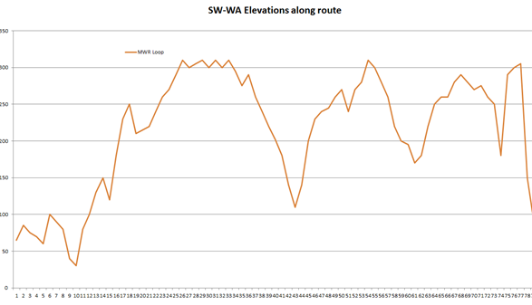
Note- Vertical axis in m, Horizontal axis in Km
Pictures from Route-
Map of Route-
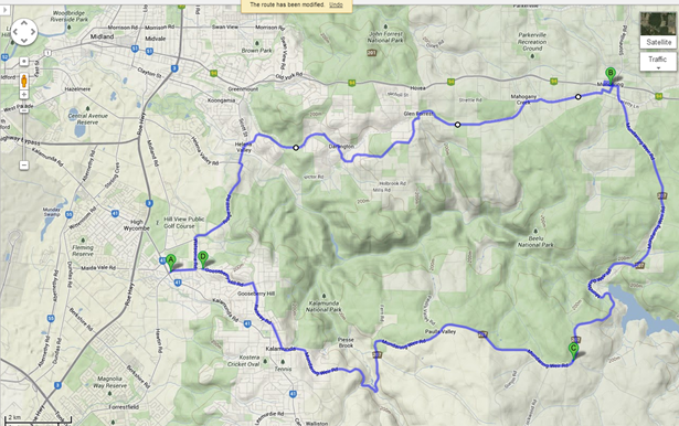
Verdict-
A great drive past plenty of old WA homes, history and nice scenery but highly prohibitive speed limits (60 to 80kmh max). Holidays and weekends in summer are best avoided unless you want the ambiance of folk out on the road. Best driven in midweek or during rainy weather. Nice and close to Perth. The weir is worth a stop and a walk and I always liked the MW hotel for a refreshing break/ lunch. Often interesting cars, bikes groups to be seen in the various car parks along the way.
Chitty Chitty Fang Fang
Route Statistics-
| Start Distance From Perth (km) | 42 |
| Route Distance | 74 |
| Start Elevation (m) | 45 |
| Total Climb (m) | 621 |
| Total descent (m) | -581 |
| Max elevation (m) | 218 |
| End elevation (m) | 105 |
| No of bends | 82 |
| Max gradient | 5% |
| Surface | Sealed |
| Traffic | Moderate |
| Max speed limit | 110kmh |
| Speed camera Likelyhood | Moderate |
Directions-
- Start at Bullsbrook turning onto chittering Rd Follow for approx. 30km
- Enter chittering
- Exit chittering to north and pass by lakes nature reserve
- Rejoin Great northern HWY turn right
- Enter Bindoon pass through heading North
- Approx 4km out of Bindoon Turn left onto Bindoon Moora Rd
- Turn left onto Mooliabeenee Rd
- After Approx 15km End in Gingin

Note- Vertical axis in m, Horizontal axis in Km
Pictures from Route-
Map of Route-
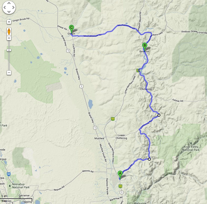
Verdict-
A longer drive with rounder rolling hills than routes south of Perth into the Darling ranges. Roads are more open and bends are longer and sweeping. Bindoon Bakery is a popular stop for Bikers and drivers alike and Gin Gin is a nice end to the drive before jumping on a southerly highway back to Perth along the flat ocean plain. Alternative return routes are along the coastal road.
Great work! Have bookmarked this thread.
Tried Google maps, still too hard and horribly un-intuitive. you covered much of my example in any case. Basically:
From Byford take Nettleton Road
Dogleg left then right in Jarrahdale onto Kingsbury Drive
Down SW Highway to North Dandalup
Left onto Del Park Road
Follow Del Park to Dwellingup
Right onto Pinjarra Williams Road to Pinjarra
North on SW Highway for half a km then right onto Alcoa Road
Before the refinery turn left onto North Spur Road, back to Del Park and turn left then do Del Park in reverse back to North a Dandalup
That was our regular Sunday morning route on our Sports bikes years ago. Cracking drive.
The Avon Ascent
(aka Pioneers Trail)
Route Statistics-
| Start Distance From Perth (km) | 19 |
| Route Distance | 72 |
| Start Elevation (m) | 25 |
| Total Climb (m) | 977 |
| Total descent (m) | -882 |
| Max elevation (m) | 401 |
| End elevation (m) | 130 |
| No of bends | 101 |
| Max gradient | 18% |
| Surface | Sealed (Unsealed gravel for 8km if lovers lane is taken) |
| Traffic | low to Moderate |
| Max speed limit | 110kmh |
| Speed camera Likelyhood | Moderate to High |
Directions-
- Start at Middle swan on Route 50 and Hwy1 Toodyay rd
- Remain on Toodyay rd up red hill
- Enter Gidgegannup after approx. 25km
- Approx. 18km out of Gidgegannup turn left on Morangup rd (Or stay on Toodyay rd to toodyay)
- After Approx 10km. Meet junction with Lovers lane (unsealed) turn left and cross ford until road is adjacent with Avon river (Toodyay scenic route or Pioneers trail)
- Road becomes sealed for some sections but after 6km junction with Sandplain rd (Sealed)turn right and head uphill for some good views and nice tarmac (if continuing straight will meet Jumlimar rd and turn right to get into Toodyay)
- Continue on Sandplain and descend back to toodyay main rd
- Turn left on Toodyay rd and head approx 5km into toodyay
- End at Coke museum, Masonic Hotel or toodyay mill
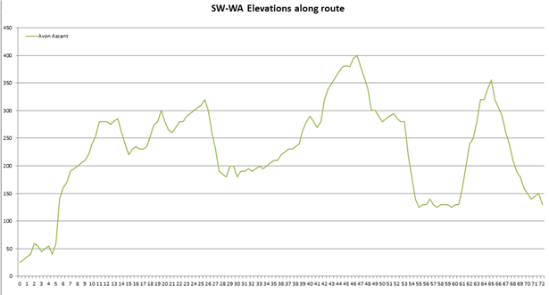
Note- Vertical axis in m, Horizontal axis in Km
Pictures from Route-
Map of Route-
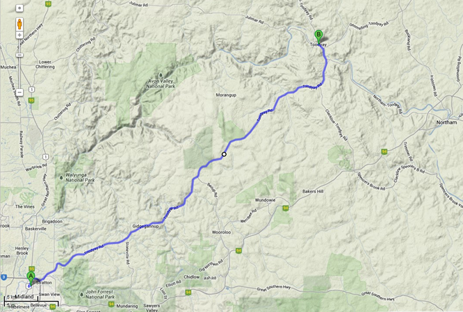
Verdict-
A well established, known drive with long sweeping bends open straights with reasonable visibility and guaranteed empty sections of road along the pioneers trail. The short sections of unsealed road are bearable but better if you have something 4wd and fast. The whole route can be driven on Toodyay rd but traffic and speed camera presence here is higher than off the alternate routes (Pioneers trail down Lovers lane and Morangup rd. The proper Avon river experience isn't had if you stick to toodyay rd either. Once in Toodyay, there are many options for the return trip. This was the 1st ride I was taken on by the RATs when I got to Perth and after being told it was all flat and boring with straight roads in the whole of WA I was pleasantly surprised by the twisty, empty rds and elevation changes.
Gassing Station | Australia | Top of Page | What's New | My Stuff


